Africa Studies | United Nations
Article By Efrata Eshetu
September 9, 2026 10:58 am EDT
The United Nations Adopts Landmark “Correct the Map” Resolution
The push to replace Mercator maps is forcing governments and institutions to reconsider how geography shapes perceptions of Africa.
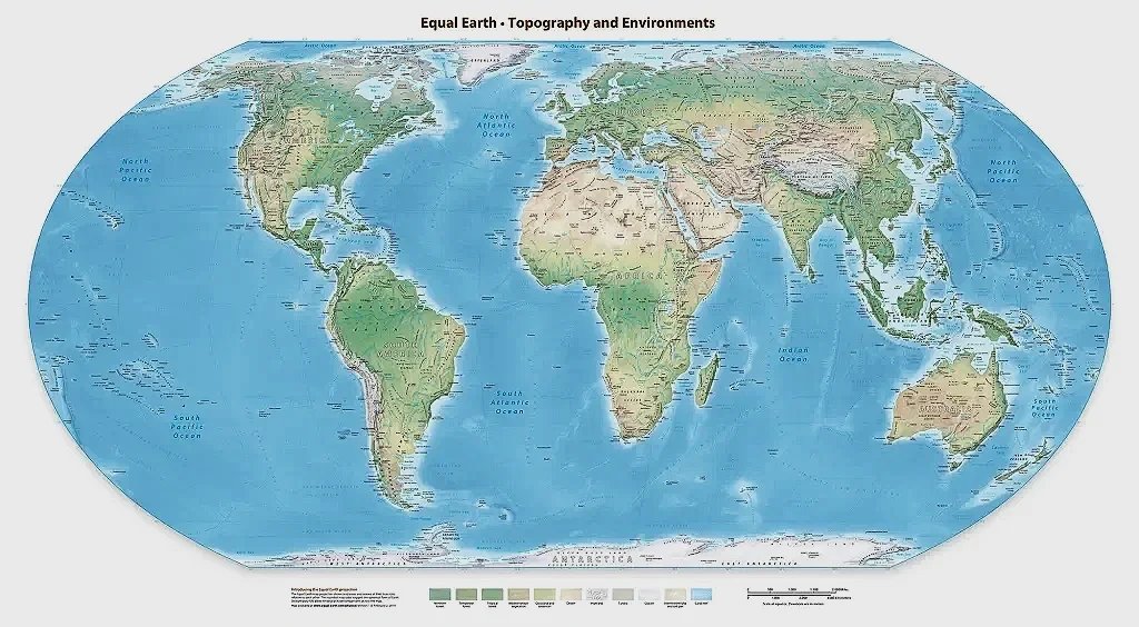
The Equal Earth projection preserves the relative area of continents and landmasses and is one of the equal-area projections promoted by the United Nations’ “Correct the Map” resolution. Map credit: Tom Patterson/Equal-Earth.com
On September 4, 2026, the United Nations General Assembly adopted the “Correct the Map” resolution, an African-led initiative introduced by Togo on behalf of the African Group and backed by the African Union. This non-binding resolution encourages international organizations, governments, educational institutions, and technology companies to move away from the centuries-old Mercator projection when depicting relative landmass sizes and instead use the Equal Earth map developed in 2018, or other equal-area projections. The resolution passed with 164 members voting in favor. Six countries abstained: Estonia, Georgia, Lithuania, Moldova, Serbia, and Ukraine. The United States was the only country to vote against the resolution.
Speaking on behalf of the United States before the vote, Yaryna Ferencevych, Deputy U.S. Representative to the UN Economic and Social Council, argued that the initiative could not be separated from what she described as “the much larger and more radical ideological project it belongs to.” Although the United States dismissed the initiative as ideological, the resolution draws on a longstanding debate over cartographic distortion, Eurocentrism, and the ways maps can reinforce perceptions shaped by colonialism and Western political power.
How the Mercator Map Distorts Global Scale
The “Correct the Map” resolution aims to provide a more accurate representation of the relative size of regions, especially Africa and other Global South countries, while challenging standard and commonly used maps that distort and minimize them. This distortion results from the technique behind the Mercator map, which projects the Earth’s surface onto a cylinder and unrolls it into a flat plane. To preserve the shapes of small regions, lines of latitude are spaced progressively farther apart as they move away from the equator. While this technique preserves angles and makes lines of constant compass bearing appear straight, which made the projection especially useful for navigation, it alters landmass sizes the farther they are from the equator. On the Mercator map, area distortion is minimal near the equator but increases toward the poles, and this creates an unbalanced perspective of regions by making high-latitude areas such as North America and Europe appear disproportionately large relative to regions closer to the equator. These distortions make Greenland appear roughly comparable in size to the continent of Africa, even though Africa is approximately 14 times larger. The map also makes Europe appear much closer in size to Africa than it actually is, despite Africa being about three times larger.
Togolese Foreign Minister Robert Dussey, who led negotiations on the resolution on behalf of the African Group, argued that commonly used world maps can distort perceptions of Africa’s size and importance and influence how the continent is viewed internationally. In a briefing to the African Group before the vote, he said that maps shape perceptions and can perpetuate representations that do not correspond to geographic reality. The resolution similarly links inherited distortions in the relative size of continents to misconceptions and what it describes as the “symbolic minimization of Africa in collective imaginations.”
Dussey has framed the resolution as an effort to correct geographic misconceptions and ensure that Africa is represented according to its actual scale and place in the world. But to better understand how these misconceptions developed over time, it is necessary to look back at the origins of the Mercator projection and the historical debate over how the world is represented on maps.
The Historical Roots of the Modern Debate
At the height of the Age of Exploration, Flemish cartographer Gerardus Mercator created the Mercator map in 1569, intended mainly for navigation. Mercator projected the spherical Earth onto a flat surface by creating a cylindrical map projection and flattening it. This innovation allowed sailors to plot and follow courses using straight lines that represented constant compass bearings. Though designed as a nautical tool, by the late 19th century it became commonly used in world map publications and for commercial and educational purposes.
German historian Arno Peters became one of the most prominent critics of the Mercator projection in the 20th century. At a May 1973 press conference in Bonn, West Germany, Peters presented an equal-area world map as an alternative to Mercator and argued that the older projection reinforced a Eurocentric view of the world by exaggerating the apparent size of countries in Europe and North America. His map became known as the Peters projection, and later the Gall–Peters projection after cartographers pointed out that Scottish clergyman James Gall had described essentially the same projection in 1855. Unlike Mercator, the Gall–Peters projection preserves the relative area of countries and continents, but it distorts their shapes by stretching or compressing regions depending on their latitude.
In 2017, Boston Public Schools began phasing in the Gall–Peters projection across the district. Colin Rose, then assistant superintendent for opportunity and achievement gaps, said the change was part of an effort to “decolonize the curriculum” and challenge what he described as a Eurocentric representation of the world. In an interview with WBUR, Hayden Frederick-Clarke, then Boston Public Schools’ director of cultural proficiency, said that commonly used maps made many places tied to students’ heritage appear “small and insignificant.” Boston officials also said they believed the district was the first public school system in the United States to adopt the projection systemwide.
After Boston Public Schools began using the Gall–Peters projection, the resulting national and international media coverage drew the attention of cartographers Bojan Šavrič, Tom Patterson, and Bernhard Jenny, who later wrote that the coverage “motivated the creation” of the Equal Earth projection. Introduced in 2018, Equal Earth is an equal-area projection that preserves relative landmass sizes while presenting continental shapes more naturally than Gall–Peters. Equal Earth would later become one of the alternative projections promoted by the United Nations in the 2026 “Correct the Map” resolution.
The Trump Administration’s Recent Controversies Involving Africa
The discussion surrounding accurate mapping also gained attention following backlash faced by the U.S. State Department over a map displayed during the AIDS 2026 Conference in Rio de Janeiro, where all six African countries highlighted on the map were incorrectly identified. The map placed Mozambique near Ethiopia, Côte d’Ivoire appeared on the opposite side of the continent, Uganda and Malawi were shown in roughly the correct regions but with inaccurate borders, Cameroon appeared in the legend but was not identified on the map, and Nigeria was shown as a landlocked country in the Sahara.
A State Department spokesperson called the incident an “unfortunate error” and said it was caused by a team member who hastily altered the slide deck immediately before the presentation. The department also said it took “full responsibility” for the confusion and misrepresentation caused for attendees, including its African partners.
The mislabeled map incident follows a series of controversies involving the Trump administration and African countries. During a White House meeting with five African leaders in July 2025, President Donald Trump praised Liberian President Joseph Boakai’s English and asked where he had learned to speak it, even though English is Liberia’s official language. Since returning to office, Trump has also imposed entry restrictions affecting several African countries, including Chad, the Republic of Congo, Equatorial Guinea, Eritrea, Libya, Somalia, and Sudan. The administration has defended the restrictions by arguing that deficiencies in some countries’ information-sharing, identity-management, screening, and vetting systems make it harder for U.S. officials to properly assess their nationals.
What Comes Next After the Resolution
Though the “Correct the Map” resolution neither bans the Mercator projection nor mandates the use of alternative projections, countries have already begun announcing changes to how they use world maps. And because the resolution is non-binding, implementation will depend on whether governments and institutions choose to change the projections they use.
France’s Minister for Europe and Foreign Affairs, Jean-Noël Barrot, announced that the French Foreign Ministry will no longer use the Mercator projection in its diplomatic practices and will instead use cartographic representations better suited to their intended purpose and more faithful to actual land areas. Togo is similarly preparing to change the geography materials used in its schools by the end of 2026. Foreign Minister Robert Dussey said the country intends to become the first to update its school maps following the resolution. Togo also plans to meet with African Union member states and supporters from other regions within six months to discuss how to expand the adoption of equal-area projections. Dussey said those discussions will include companies involved in mapping, GPS, and other location-based technologies.
The African Union Commission has committed to working with Togo, member states, and other partners to support implementation of the resolution.
Author Bio: Efrata Eshetu is a fourth-year undergraduate student at Middlebury College, where she majors in International Politics and Economics and minors in Global Health. Her academic interests center on African migration, women’s rights, and the intersection of religion and policymaking across the continent.
Read More
U.N. Resolution Declares Transatlantic Slave Trade the Gravest Crime against Humanity
June 22, 2026
By Abryana Kevelier-Williams
Oprah Winfrey’s South African Girls’ Academy to End Operations in 2027
August 5, 2026
By Zachary Burden